While many associate climate change with rising sea levels, the most visible threat to some of the world's largest urban centers is actually the ground beneath their feet. Mexico City is sinking, and recent data suggests this slow-motion crisis is accelerating at a rate that could fundamentally reshape the capital.
Recent findings from a NASA satellite partnership have revealed alarming shifts in the city's topography, exposing vulnerabilities that threaten millions of residents through land subsidence rather than flooding.
The Mechanics Behind Why Mexico City Is Sinking
The foundation of Mexico City rests on layers of clay and lake bed deposits left behind by the ancient Lake Texcoco. For decades, massive groundwater extraction to meet the demands of a growing population has stripped away the soil's structural integrity.
As this water is removed, the earth compacts, leading to a phenomenon known as differential subsidence. This process causes different neighborhoods to sink at wildly different rates, creating several critical issues:
- Uneven ground shifts: Some areas descend by up to two centimeters per month.
- Infrastructure damage: Roads buckle and pipelines rupture under the stress of shifting earth.
- Structural instability: Buildings face heightened risks as foundations move unpredictably.
How NASA Satellite Technology Tracks Ground Movement
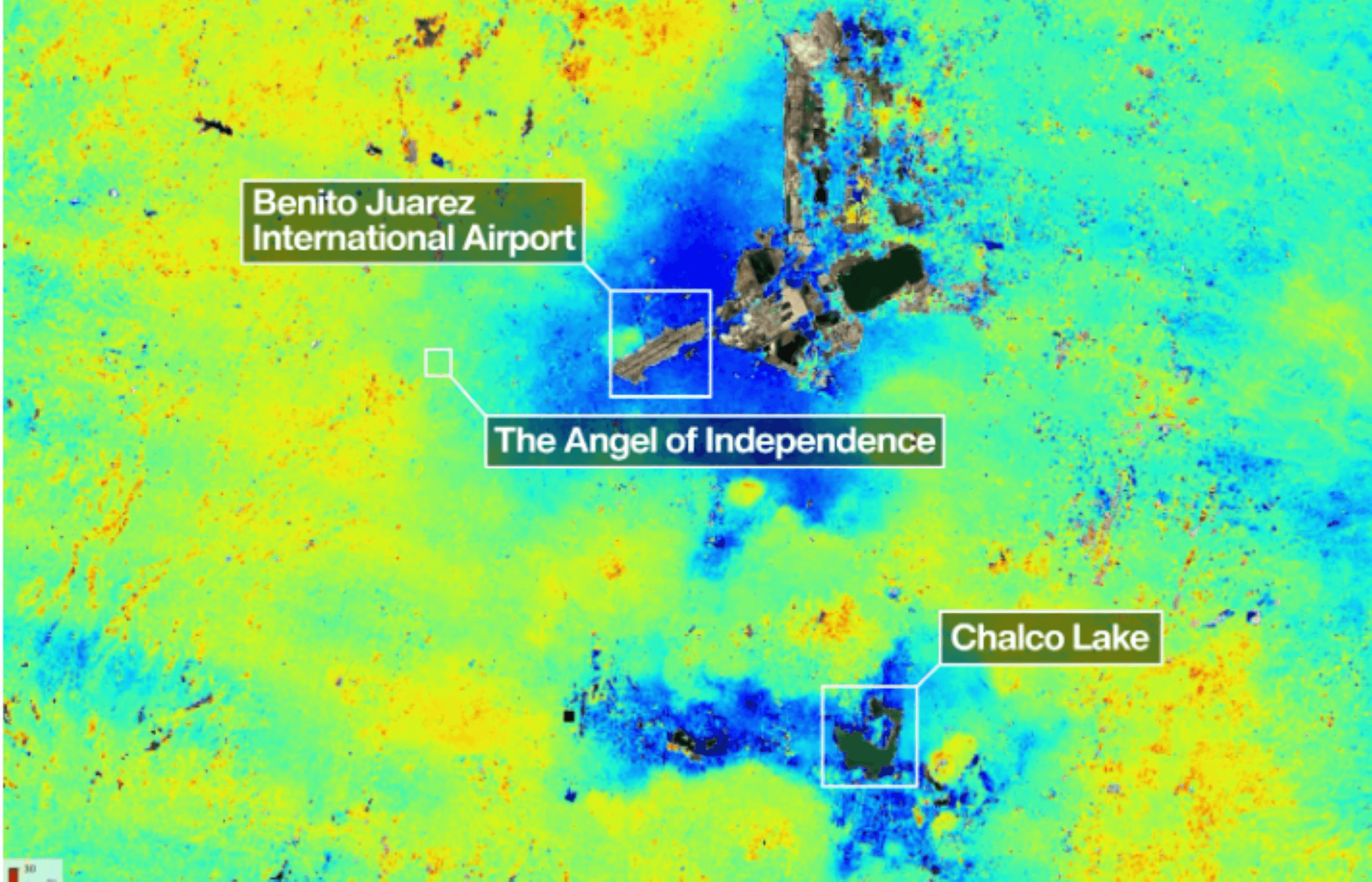
To combat this growing threat, NASA, in collaboration with the Indian Space Research Organisation (ISRO), utilized the NISAR satellite. This mission is equipped with dual-frequency synthetic aperture radar designed to capture millimeter-level elevation shifts across vast landscapes.
During its initial data cycle from late 2025 through early 2026, the NISAR mission produced highly detailed maps that pinpointed specific subsidence hotspots. The findings confirmed suspicions that certain districts are losing as much as half a meter of elevation annually. This level of precision allows for targeted interventions rather than relying on broad, speculative urban planning.
Implications for Global Urban Infrastructure
The data provided by the NASA satellite serves as a wake-up call for policymakers worldwide. Infrastructure designed decades ago is simply not equipped to handle these new geophysical realities. As water mains rupture and transit systems face misalignment, the cost of reactive repairs is expected to soar.
Mexico City’s situation provides a cautionary blueprint for other global megacities built on compressible sediments, such as Jakarta and Tokyo. However, the integration of high-frequency radar imagery with predictive modeling offers a way forward. By using satellite-derived elevation changes, authorities can transition from reactive fixes to proactive resilience, forecasting risk zones before catastrophic failures occur.